Showing posts with label mouth. Show all posts

Sunday, November 12, 2006

Lower Course of the River - Floodplains and Levées

Moving between the Middle and Lower Course of the River


As a river continues its journey towards the sea, the valley cross section continues to become wider and flatter with an extensive floodplain either side of the channel. The river erodes laterally and deposition also becomes important. By the time it reaches the lower course the river is wider and deeper and may contain a large amount of suspended sediment.

When the river floods over the surrounding land it loses energy and deposition of its suspended load occurs. Regular flooding results in the building up of layers of nutrient rich alluvium which forms a flat and fertile floodplain.

When the river water bursts its bank, the shallower depth of water flowing over the surface results in frictional drag and a consequent reduction in velocity (speed) of flow. This results in the loss of energy and therefore deposition occurs. The heaviest materials are deposited first as these require the most energy to be transported and therefore build up around the sides of the river forming raised banks known as Levées (click on diagram above). Finer material such as silt and fine clays continuing to flow further over the floodplain before they are deposited.

Find out more:
See these Wikipedia articles on floodplains and on natural and artificial levées This article called "Raising the Bar for Levees" looks at the role of Levees in flood protection an idea we will come back to in a few lessons time when we look at the causes, effects and management of river floods.

Visualising Floodplain and Levée formation
A nice animation showing the development of a floodplain and Levées Floodplain animation

Key Term Check

Floodplain - the area of land around a river channel which is formed during times of flood when the amount of water in a river exceeds its channel capacity and deposition of rich silt occurs.

Levées - a raised river bank (can be natural features formed by deposition or artificial structures built to increase channel capacity and reduce flood risk)

Friday, November 10, 2006

Rivers - Source to Mouth

Having understood the basics of a Drainage Basin we now need to consider the journey that a river within a Drainage Basin takes from its beginning to its end. The path the river follows from its source to mouth is known as the river's course. When studying rivers we often divide it into 3 main sections, the upper course; middle course and lower course. Each part of the river has distinctive features which form and the characteristics of the river and its surrounding valley change downstream (click on the diagram to see the main changes)

The photographs on this site show some examples of how the landscape changes along the course of a river.


The Drainage Basin

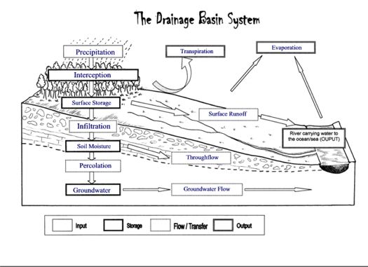
The land based part of the hydrological cycle is called the Drainage Basin System. A drainage basin is the name given to the area of land which is drained by a river. When water reaches the surface there are a number of routes which it may take in its journey to reach the river. These are shown in the diagram opposite.


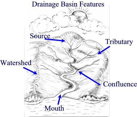
Drainage Basins have a number of distinct features which you need to be able to name and identify. The edge of a drainage basin is characterised by the highest points of land around the river, this is known as the watershed. The point at which a river starts is called its source. As the river continues to flow down stream it may be joined by smaller rivers called tributaries. The point at which these smaller rivers join the main river is known as a confluence. As the river continues its journey, eventually reaches the sea - the point where the river flows into the sea is known as the river mouth.

Finding out more.....

Check out this great animation on watersheds

In a few lessons time we will be starting to think about the characteristics of different drainage basins and how these can affect the pathways water takes and how quickly water that falls as precipitation reaches the river. Start thinking about this by reading this article on Drainage Basin.

Now Check your understanding...

Try out this Hydrological Cycle / Drainage Basins Walk the Plank Game
and check your understanding of Drainage Basin Features by matching up these key terms and definitions within the 30 second time limit!