The Drainage Basin
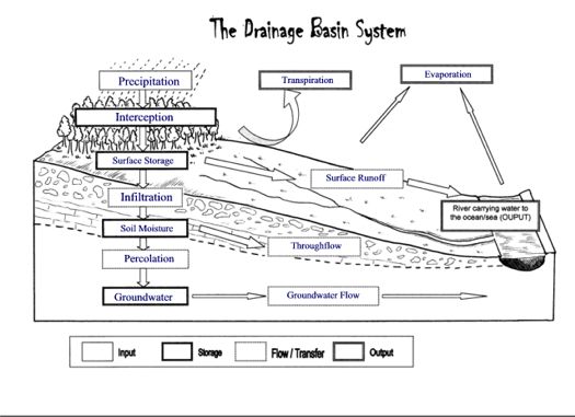 The land based part of the hydrological cycle is called the Drainage Basin System. A drainage basin is the name given to the area of land which is drained by a river. When water reaches the surface there are a number of routes which it may take in its journey to reach the river. These are shown in the diagram opposite.
Drainage Basins have a number of distinct features which you need to be able to name and identify. The edge of a drainage basin is characterised by the highest points of land around the river, this is known as the watershed.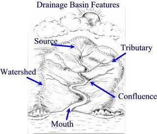 The point at which a river starts is called its source. As the river continues to flow down stream it may be joined by smaller rivers called tributaries. The point at which these smaller rivers join the main river is known as a confluence. As the river continues its journey, eventually reaches the sea - the point where the river flows into the sea is known as the river mouth.
Finding out more.....
Check out this great animation on watersheds
In a few lessons time we will be starting to think about the characteristics of different drainage basins and how these can affect the pathways water takes and how quickly water that falls as precipitation reaches the river. Start thinking about this by reading this article on Drainage Basin.
Now Check your understanding...
Try out this Hydrological Cycle / Drainage Basins Walk the Plank Game
and check your understanding of Drainage Basin Features by matching up these key terms and definitions within the 30 second time limit!
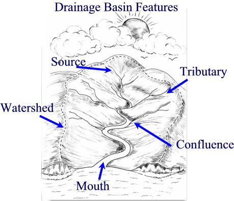 The point at which a river starts is called its source. As the river continues to flow down stream it may be joined by smaller rivers called tributaries. The point at which these smaller rivers join the main river is known as a confluence. As the river continues its journey, eventually reaches the sea - the point where the river flows into the sea is known as the river mouth.
Finding out more.....
Check out this great animation on watersheds
In a few lessons time we will be starting to think about the characteristics of different drainage basins and how these can affect the pathways water takes and how quickly water that falls as precipitation reaches the river. Start thinking about this by reading this article on Drainage Basin.
Now Check your understanding...
Try out this Hydrological Cycle / Drainage Basins Walk the Plank Game
and check your understanding of Drainage Basin Features by matching up these key terms and definitions within the 30 second time limit!
![]()


No comments:
Post a Comment