Friday, November 17, 2006

Hydrographs and River Discharge

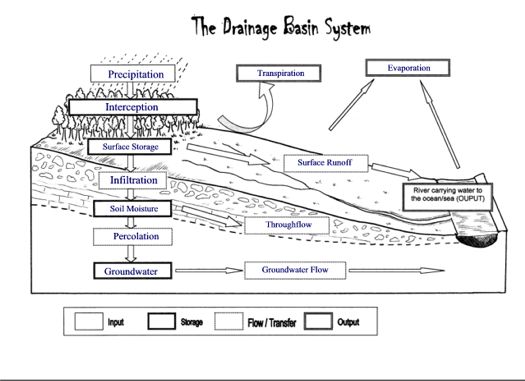
What are Hydrographs?

The amount of water in a river at any given point and time is known as the discharge which is measured in cumecs (cubic metres per second). This can be calculated by multiplying river velocity by channel volume at a given point and time.


Hydrographs are graphs which show river discharge over a given period of time and show the response of a drainage basin and its river to a period of rainfall.


A storm hydrograph shows how a river's discharge responds following a period of heavy rainfall. On a hydrograph, the flood is shown as a peak above the base (normal) flow of the river. Analysis of hydrographs can help hydrologists to predict the likelihood of flooding in a drainage basin. The response of a river to a rainfall event can be measured in terms of the lag time - the time between peak rainfall and peak discharge. Rivers with a short lag time respond rapidly to rainfall events and are therefore more prone to flooding than rivers with a longer lag time

River discharge does not respond immediately to rainfall inputs as only a little of the rainfall will fall directly into the channel. The river will start to respond initially through inputs from surface runoff (the fastest flow of water) and its discharge will later be supplemented through inputs from throughflow and groundwater flow.


Variations in the shape of a Hydrograph:

The shape of a hydrograph is determined by the speed in which flood waters are able to reach the river. The nature of the drainage basin therefore has a great influence on the way a river responds to a river as it will determine the types and speeds of the flow of water to the river.

The fastest route to the river is via overland flow. If most of the water in a drainage basin travels in this way, a river will respond quickly to heavy rainfall and the hydrograph shape will be 'peaky' (graph A) with steep rising and recessional limbs. The lag time will be short and there will be a greater risk of flooding. Where more water is able to pass into the soil and travel to the river via throughflow / groundwater flow, there will be a slower rise in discharge and the river will respond slower (graph B). The lag time will be longer and the risk of flooding will be much lower.


Factors affecting a flood hydrograph:

Characteristics of the Drainage Basin:
  • - impermeable rocks (e.g. granite) and soil (e.g. clay) will not allow water to pass through, resulting in large amounts of surface runoff and a greater flood risk as rivers respond quickly - results in a short lag time.
  • - permeable rocks and soil have a high infiltration capacity and will absorb water quickly, reducing overland flow - results in a longer lag time
  • - a drainage basin with a steep gradient will result in greater overland flow and a shorter lag time than where the gradient is less steep allowing more time for infiltration to occur.

Type and amount of Precipitation:
  • - heavy rain results in rapid saturation of the upper soil layers and the excess water therefore reaches streams quickly as surface runoff (short lag time)
  • - slow light rain can be absorbed by infiltration and the river takes longer to respond to rainfall as water takes longer to pass through the drainage basin via throughflow and groundwater flow (longer lag time)

Land Use and Human Impact
  • - impermeable man made surfaces such as concrete and tarmac are impermeable therefore rivers in urban drainage basins tend to have short lag times due to higher amounts of surface runoff and drainage systems taking water to rivers quickly.
  • - vegetated areas help to reduce flood risk by increasing the time it takes for water to reach a river (longer lag time) by encouraging infiltration (roots opening up the soil), intercepting water by their leaves and taking up water in their roots.
  • - areas cleared by deforestation will respond quickly to rainfall due to the reduced interception
Size of the Drainage Basin
  • - Large Drainage Basin - water will take longer to reach the river (long lag time)
  • - Small Drainage Basin - water will enter the river quicker (short lag time)
Present conditions of the Drainage Basin
  • - If the soil has already been saturated by heavy rain its infiltration capacity will be reduced and further rain will go as surface runoff
  • - If the soil is dry it will be able to absorb more water during infiltration and therefore the lag time will be longer
  • - if the ground surface is frozen lag time is short as water cannot infiltrates and passes quickly to the river as runoff

River Management
  • - the presence of a dam will allow flow to be controlled, reducing flood risk and allowing rivers to gradually respond to heavy rainfall in a controlled way;
Now check your understanding of the factors affecting lag time - by playing this lag time quiz - sort out the factors you are given into whether they would result in a long or short lag time - see how quickly you can sort them accurately!


Follow up links:
Try out this fantastic interactive module on hydrographs and flooding - learn about how discharge is calculated and watch the animated development of a hydrograph during a virtual rainfall event. Make sure you also try out the flood model - change the land-use in the virtual drainage basin and watch what happens to the rivers discharge and associated hydrograph when you 'flood' the basin!

GCSE Bitesize Revision - Flood hydrographs

Here is a fantastic powerpoint to remind you of how hydrographs are constructed and the factors that affect them - great for revision! Many thanks to Ollie Bray of Mussleburgh Grammar School for sharing this! (If you do not have powerpoint on your computer you can download a free powerpoint viewer here which will then let you view the file)


Revision / Exam Tips:
  1. make sure you are able to calculate lag time - you may be given a hydrograph in an exam and be expected to give the lag time
  2. when quoting lag time, discharge, rainfall etc.. from a hydrograph make sure you include the relevant units in your answer! (i.e. hours, cumecs, mm etc.)
  3. make sure you are able to discuss the factors that result in long or short lag times and thus affect the likelihood of a drainage basin flooding.


Key Terms Check:

Discharge - this is the amount of water in a river at any given point and time. Discharge is measured in cumecs (cubic metres per second)

Velocity - speed of a river (measured in metres per second)

Hydrograph - a graph showing changes in river discharge over time in response to a rainfall event.

Lag time - the time taken between peak rainfall and peak discharge

Rising Limb - shows the increase in discharge on a hydrograph

Falling Limb - shows the return of discharge to normal / base flow on a hydrograph

Peak Rainfall - maximum rainfall (mm)

Peak Discharge - maximum discharge (cumecs)

Sunday, November 12, 2006

Lower Course of the River - Floodplains and Levées

Moving between the Middle and Lower Course of the River


As a river continues its journey towards the sea, the valley cross section continues to become wider and flatter with an extensive floodplain either side of the channel. The river erodes laterally and deposition also becomes important. By the time it reaches the lower course the river is wider and deeper and may contain a large amount of suspended sediment.

When the river floods over the surrounding land it loses energy and deposition of its suspended load occurs. Regular flooding results in the building up of layers of nutrient rich alluvium which forms a flat and fertile floodplain.

When the river water bursts its bank, the shallower depth of water flowing over the surface results in frictional drag and a consequent reduction in velocity (speed) of flow. This results in the loss of energy and therefore deposition occurs. The heaviest materials are deposited first as these require the most energy to be transported and therefore build up around the sides of the river forming raised banks known as Levées (click on diagram above). Finer material such as silt and fine clays continuing to flow further over the floodplain before they are deposited.

Find out more:
See these Wikipedia articles on floodplains and on natural and artificial levées This article called "Raising the Bar for Levees" looks at the role of Levees in flood protection an idea we will come back to in a few lessons time when we look at the causes, effects and management of river floods.

Visualising Floodplain and Levée formation
A nice animation showing the development of a floodplain and Levées Floodplain animation

Key Term Check

Floodplain - the area of land around a river channel which is formed during times of flood when the amount of water in a river exceeds its channel capacity and deposition of rich silt occurs.

Levées - a raised river bank (can be natural features formed by deposition or artificial structures built to increase channel capacity and reduce flood risk)

Saturday, November 11, 2006

Middle Course of the River - Meanders & Ox-bow Lakes

The Middle Course of a River
Having studied the characteristics of a river in its upper reaches we now need to follow the river as it enters its middle course. Here the river channel has become much wider and deeper as the channel has been eroded and the river has been fed by many tributaries upstream. Consequently, despite the more gentle gradient the velocity of flow may be as fast as in the uplands. As well as changes in the river channel, its surrounding valley has also become wider and flatter in cross-section with a more extensive floodplain. One of the most distinctive features of the river in the middle course is its increased sinuousity. Unlike the relatively straight channel of the upper course, in the middle course there are many meanders (bends) in the river.


Meander Formation

Meanders form due to the greater volume of water carried by the river in lowland areas which results in lateral (sideways) erosion being more dominant than vertical erosion, causing the channel to cut into its banks forming meanders.


1. Water flows fastest on the outer bend of the river where the channel is deeper and there is less friction. This is due to water being flung towards the outer bend as it flows around the meander, this causes greater erosion which deepens the channel, in turn the reduction in friction and increase in energy results in greater erosion. This lateral erosion results in undercutting of the river bank and the formation of a steep sided river cliff.

2. In contrast, on the inner bend water is slow flowing, due to it being a low energy zone, deposition occurs resulting in a shallower channel. This increased friction further reduces the velocity (thus further reducing energy), encouraging further deposition. Over time a small beach of material builds up on the inner bend; this is called a slip-off slope.

Remember - a meander is asymmetrical in cross-section (see diagram). It is deeper on the outer bend (due to greater erosion) and shallower on the inside bend (an area of deposition).


Over time meanders gradually change shape and migrate across the floodplain. As they do so meander bends becomes pronounced due to further lateral erosion and eventually an ox-bow lake may form.

Ox-Bow Lake formation


  1. As the outer banks of a meander continue to be eroded through processes such as hydraulic action the neck of the meander becomes narrow and narrower.
  2. Eventually due to the narrowing of the neck, the two outer bends meet and the river cuts through the neck of the meander. The water now takes its shortest route rather than flowing around the bend.
  3. Deposition gradually seals off the old meander bend forming a new straighter river channel.
  4. Due to deposition the old meander bend is left isolated from the main channel as an ox-bow lake.
  5. Over time this feature may fill up with sediment and may gradually dry up (except for periods of heavy rain). When the water dries up, the feature left behind is knwon as a meander scar.
Visualising Meander formation:
Key Terms Check:
  • Meander - a bend in a river
  • River Cliff - a small cliff formed on the outside of a meander bend due to erosion in this high energy zone.
  • Slip off Slope - a small beach found on the inside of a meander bend where deposition has occured in the low energy zone.
  • Ox-bow lake - a lake formed when the continued narrowing of a meander neck results in the eventual cut through of the neck as two outer bends join. This result in the straightening of the river channel and the old meander bend becomes cut off forming an ox-bow lake.
  • Meander scar - feature left behind when the water in an ox-bow lake dries up.

Natural World - Iguacu Falls


Natural World on Wednesday 15th November at 8.00pm on BBC 2 looks at the stunning Iguacu falls on the Brazil/Argentina border. This waterfall is 3 times wider than the Niagara Falls and is surrounded by rainforest.

Photographs from Wikipedia Creative Commons (Share Alike Licence) http://commons.wikimedia.org/wiki/Image:Iguacu-001.jpg#file http://commons.wikimedia.org/wiki/Image:Iguacu-003.jpg Author: Reinhard Jahn, Mannheim

Friday, November 10, 2006

Upper Course of the River: Waterfalls

An other feature found in the upper course of a river, where vertical erosion is dominant, is a waterfall. The highest waterfall in the world is the Angel Falls in Venezuela (see picture right) which have a drop of 979m. Other particularly famous examples include Niagara Falls (North America), the Victoria Falls (on the Zambia / Zimbabwe border) and the Iguazu Falls (South America).


Although much smaller in scale, there are many waterfalls in the upper course of UK rivers (e.g. Thornton Falls, Yorkshire - above), but how do they form?


The formation of Waterfalls


1.Waterfalls are found in the upper course of a river. They usually occur where a band of hard rock lies next to soft rock. They may often start as rapids.

2. As the river passes over the hard rock, the soft rock below is eroded (worn away) more quickly than the hard rock leaving the hard rock elevated above the stream bed below.

3. The 'step' in the river bed continues to develop as the river flows over the hard rock step (Cap Rock) as a vertical drop.

4. The drop gets steeper as the river erodes the soft rock beneath by processes such as abrasion and hydraulic action. A plunge pool forms at the base of the waterfall.


5. This erosion gradually undercuts the hard rock and the plunge pool gets bigger due to further hydraulic action and abrasion.Eventually the hard cap rock is unsupported and collapses. The rocks that fall into the plunge pool will continue to enlarge it by abrasion as they are swirled around. A steep sided valley known as a gorge is left behind and as the process continues the waterfall gradually retreats upstream.


Visualising Waterfall Formation:

The labelled diagram of a cross section through a waterfall below, shows the formation process (click on diagram for a larger version).
There are also number of excellent animations on the internet which can help you visualise how a waterfall forms. Try out the following:

1. A good step by step animation of waterfall formation showing all the main stages involved (Wycombe High School)
2. This simple but excellent animation showing an aerial view of waterfall formation clearly shows the development of a gorge as the waterfall retreats upstream! (Cleonet)
3. An animation of waterfall formation from a different 3-dimensional perspective. Look carefully at how the plunge pool is enlarged during the formation process. (Classzone)


Key Term Check:

  • Cap Rock - layer of hard resistant rock forming the 'step' over which the 'falls' occur in a waterfall.

  • Waterfall - a cascade of water over a hard rock step in the upper course of a river

  • Plunge Pool - a deep pool beneath

  • Gorge - a steep sided valley left behind as a waterfall retreats upstream

  • Abrasion - where rocks and boulders scrape away at the river bed and banks

  • Hydraulic Action - where the force of water compresses air in cracks resulting in mini-explosions as the increased pressure in the cracks is then released.

Upper Course of the River: V-Shaped Valleys

V-Shaped Valleys

In the upper course of a river, water flows quickly through a narrow channel with a steep gradient; as it does so it cuts downwards. This vertical erosion results in a number of distinctive landforms including the steep sloping v-shaped valley through which the river flows in its upper course.


So how does a v-shaped valley form?

1. Vertical erosion (in the form of abrasion, hydraulic action and solution) in the river channel results in the formation of a steep sided valley
2. Over time the sides of this valley are weakened by weathering processes and continued vertical erosion at the base of the valley
3. Gradually mass movement of materials occurs down the valley sides, gradually creating the distinctive v-shape.
4. This material is then gradually transported away by the river when there is enough energy to do so.

As the river flows through the valley it is forced to swing from side to side around more resistant rock outcrops (spurs). As there is little energy for lateral erosion, the river continues to cut down vertically flowing between spurs of higher land creating interlocking spurs.

Visualising V-shaped Valley Formation


Key Term Check
V-shaped Valley - a valley which resembles a 'v' in cross section. These valleys have steep sloping sides and narrow bottoms.

Interlocking Spur - spurs are ridges of more resistant rock around which a river is forced to wind as it passes downstream in the upper course. Interlocking spurs form where the river is forced to swing from side to side around these more resistant ridges.

Load
- collective term for the material carried by a river

Click on the diagram above to see a larger version.

River Processes

As a river flows along its course it undertakes 3 main processes which together help to shape the river channel and the surrounding valley. These processes are erosion, transport and deposition.

RIVER EROSION
River erosion is the wearing away of the land as the water flows past the bed and banks. There are four main types of river erosion. These are:

  1. Attrition - occurs as rocks bang against each other gradually breaking each other down (rocks become smaller and less angular as attrition occurs)
  2. Abrasion - this is the scraping away of the bed and banks by material transported by the river
  3. Solution - chemicals in the river dissolve minerals in the rocks in the bed and bank, carrying them away in solution.
  4. Hydraulic Action - this is where the water in the river compresses air in cracks in the bed and banks. This results in increased pressure caused by the compression of air, mini 'explosions' are caused as the pressure is then released gradually forcing apart parts of the bed and banks.
Here is a great little animation by a teacher from Somerset (Noel Jenkins) showing the main processes of river erosion - make sure you learn them!

RIVER TRANSPORT
Material may be transported by a river in four main ways: solution, suspension, saltation and traction (see diagram). The type of transport taking place depends on (i) the size of the sediment and (ii) the amount of energy that is available to undertake the transport. In the upper course of the river there is more traction and saltation going on due to the large size of the bedload, as a river enters its middle and lower course there is alot of finer material eroded from further upstream which will be carred in suspension. Here is a great little movie showing the process of saltation.

Check out the following animation showing the processes of river transport

DEPOSITION
Deposition is where material carried by the river is dropped. This will occur when there is no longer sufficient energy to transport material. Deposition of material may result in the formation of distinctive features such as slip off slopes (on the inner bends of meanders); levees (raised banks) and of course the floodplain itself. Remember - it is the largest material that will be dropped first as it requires the most energy to be transported. eroded from further upstream which will be carried in suspension.

This animation looks at sediment deposition as a river enters a lake - look at what size material is deposited first.

Now test your understanding:
Try out these drag and drop games to match up the key processes of erosion and transport with their correct definitions.

Rivers - Source to Mouth

Having understood the basics of a Drainage Basin we now need to consider the journey that a river within a Drainage Basin takes from its beginning to its end. The path the river follows from its source to mouth is known as the river's course. When studying rivers we often divide it into 3 main sections, the upper course; middle course and lower course. Each part of the river has distinctive features which form and the characteristics of the river and its surrounding valley change downstream (click on the diagram to see the main changes)

The photographs on this site show some examples of how the landscape changes along the course of a river.


The Drainage Basin

The land based part of the hydrological cycle is called the Drainage Basin System. A drainage basin is the name given to the area of land which is drained by a river. When water reaches the surface there are a number of routes which it may take in its journey to reach the river. These are shown in the diagram opposite.


Drainage Basins have a number of distinct features which you need to be able to name and identify. The edge of a drainage basin is characterised by the highest points of land around the river, this is known as the watershed. The point at which a river starts is called its source. As the river continues to flow down stream it may be joined by smaller rivers called tributaries. The point at which these smaller rivers join the main river is known as a confluence. As the river continues its journey, eventually reaches the sea - the point where the river flows into the sea is known as the river mouth.

Finding out more.....

Check out this great animation on watersheds

In a few lessons time we will be starting to think about the characteristics of different drainage basins and how these can affect the pathways water takes and how quickly water that falls as precipitation reaches the river. Start thinking about this by reading this article on Drainage Basin.

Now Check your understanding...

Try out this Hydrological Cycle / Drainage Basins Walk the Plank Game
and check your understanding of Drainage Basin Features by matching up these key terms and definitions within the 30 second time limit!